![]()
The Mathematics of Georgia's Department of Natural Resources: Game Management
by
Mike Rosonet
Georgia's Wildlife Resources Division of the state's Department of Natural Resources uses mathematics in their work throughout the state. This essay will look at a Game Management project being done in east-central Georgia by a few people who have worked (or currently work) with the Wildlife Resource Division and show what mathematics they use and the manner in which they use mathematics, as well as what technologies aid them in their work.
My father-in-law Carroll Allen worked for over 29 years with Georgia's Department of Natural Resources in the area of Game Management. At the height of his career, he was the assistant chief of the Game Management section, which is a part of the Wildlife Resources Division. One of his responsibilities as the assistant chief was to make the budget for all of the game management projects for the state of Georgia, distributing millions of dollars to the projects and other needs that required these funds.
Now that he has retired, he has begun to do part-time work at Dylane Wildlife Management Area, which is 8100 acres of federally owned wildlife habitat in Burke County, Georgia. The people at Dylane are working specifically in the area of quail management. They evaluate quail population changes from year to year to determine if the quail population is increasing, decreasing, or remaining constant.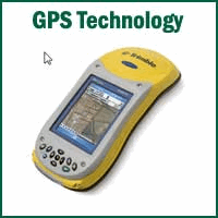
In order to establish the size of the quail population at Dylane, researchers go into the field early in the morning during the fall and listen to covey calls. (A covey is a set or small flock of birds that are gathered together. When a covey calls, it's calling to another covey.) The best time of the year to listen for covey calls is mid- to late October, and the best time of day to listen for the calls is 25 minutes before sunrise (Tall Timbers, 2010). The surveyors go to different pre-determined survey points to listen for the covey calls. When they hear a call, they plot the location that it is coming from on a map. Sometimes, researchers may use a GPS device like the one shown here to mark where they heard covey calls.
The surveyors typically adjust the covey call count that they record by comparing it to the predicted call rate; the adjusted call count is then recorded into their reports. In order to make this adjustment, they use a formula, which contains 4 different variables.
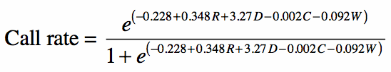
The Call Rate Formula
The formula has 4 different variables:
1. Recorded covey count,
2. The difference in barometric pressure (inches/mm Hg) from 1 A.M. to 7 A.M. of the morning that the count is conducted,
3. The percent of cloud cover (estimated to within 10%), and
4. Wind speed (km/hr: kilometers/hour)
In order to determine the difference in barometric pressure, find the recorded barometric pressure reading for 7 A.M. and subtract from it the recorded barometric pressure reading for 1 A.M. For example, if the 1 A.M. bp = 30.10 and the 7 A.M. bp = 30.12, then the value used for the difference would be: 30.12 - 30.10 = 0.02.
Surveyors typically use barometric pressure values between -0.03 and 0.03
The percentage of cloud cover can be determined from weather reports or personal estimation.
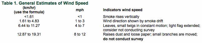
Surveyors also consider wind speed when determining if they should conduct a survey on that day. They use the following table as a reference (Tall Timbers, 2010):
Thus, if the windspeed is greater than 8 mph, the researchers will not conduct the survey on that day. Furthermore, from the table, it's plain to see that windspeeds between 0 mph and 4 mph are ideal for conducting surveys.
Once the windspeed has been determined in miles per hour (mph), the value must be converted into kilometers per hour (km/hr) through the use of the conversion: 1 mile = 1.61 kilometers.
Now that the variables have all been considered, it is time to determine the covey call count using the following formula.
Let R = the recorded call count, D = the difference in barometric pressure readings, C = the cloud cover percentage (as a percentage), and W = the wind speed. Thus, the formula reads:
Once the call rate adjustment has been calculated, divide the recorded call count by the adjustment in order to calculate the adjusted covey call count.
An Example
Let's try an example to see the mathematics that researchers are performing in the field.
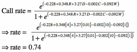
If an observer heard 4 calling coveys during a variable radius point count with weather variables measured at a difference in barometric pressures of 0.01, 10% cloud cover, and a windspeed of 1.0 km/hr, the estimated call rate based on the model/formula would be:
Finally, divide the call count by the adjusted call rate; the quotient will be the adjusted covey call count. Hence, 4/0.74 = 5.4.
The adjusted covey call count is 5.4.
A Density Estimate
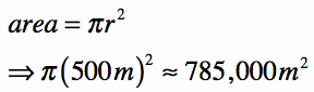
Surveyors can use the adjusted covey call count to determine a population density estimate per acre of land. These are approximations, however, and rely upon a few factors. The listening area used by the surveyors is at a constant value, 194 acres. This constant is estimated from the fact that the listening radius for surveyors is 500 meters; using the formula for the area of a circle, the area of the listening area for the surveyors is
Using the following conversion, that 1 acre = 2.471E(-4) square meters, the listening area equals 194 acres.
Also, research has shown that a surveyor is able to detect 90% of calling coveys when he or she is at a survey point within 250 meters of the coveys, given moderate terrain and vegetation cover. However, if the coveys are between 250 meters and 500 meters away from the survey point, researchers are only able to detect 40% of calling coveys (Tall Timbers, 2010).
In order to account for this discrepancy when estimating the population density, surveyors divide the number of coveys heard within 250 meters by 0.9, and they divide the number of coveys heard between 250 meters and 500 meters by 0.4; then, they add these quotients together. The sum is the estimated number of calling coveys.
This number must then be adjusted by the calling rate, which is the quotient found using the formula above. To do this, divide the estimated number of calling coveys by the calling rate, which gives the estimate of calling coveys within the listening area.
The estimated number of calling coveys must then be multiplied by the average covey size of the area. This product will yield the number of quail within the listening area. Divide this number by the listening area, the 194 acres; this quotient is the density estimate.
A Second Example
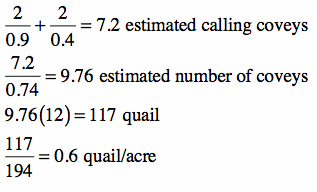
Using an estimated listening area with a radius of 500 meters, if a surveyor counted 2 calling coveys between 0 - 250 meters and 2 coveys between 250 - 500 meters, for a total of 4 calling coveys (same as the previous example, which allows us to use the call rate from the previous example), with an average covey size of 12 quail, and an estimated call rate of 0.74 (result from the previous example), the estimated density would be:
Thus, the estimated density is 0.6 quail per acre.
Extension
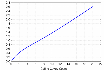
Some researchers prefer to use a table that represents the approximate density of quail using early morning covey call point counts with a 194 acre listening area. The table shown to the right represents the estimated density versus the calling covey count, which is used by many surveyors and researchers.
Attracting Quail
What brings the quail to Dylane?
The researchers employ a number of different methods in order to create and maintain an environment suitable for quail, with the hopes that it will preserve and increase the population of quail in this area of the state of Georgia. They enforce habitat management, cut down timber, and perform controlled burns in order to eliminate foreign grasses and bushes that minimize suitable habitat for quail.
Another method is to feed quail. Research shows that hens will go into their reproductive seasons better when feed is in their spread. Typically, the reproductive season occurs during June and July.
The only issue with spreading feed, which is typically grain sorghum, is that it can be considered bait for turkey and deer; baiting these wild game animals is illegal.
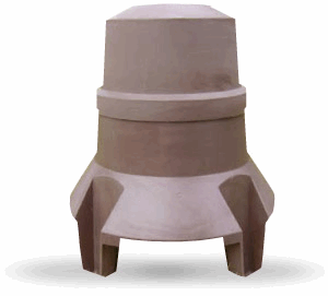
Therefore, the surveyors put out feeders, like the one shown here (Covey Base Camp, 2010). At Dylane, the researchers and surveyors have bought 200 of these feeders and put them into the quail habitat. Every 3 - 4 months, the feeders are checked in order to record how much of the food has been eaten. To do this, the feeder is weighed; the difference between the measured weight and the previously recorded weight is the amount that has been eaten between recordings. That amount is recorded, and then the feeders are filled up again.
Unfortunately, these amounts can be misleading, due to pests like woodrat nests and snakes that live or move around the areas where the feeders are placed and eat some of the feed.
In order to account for the problem with such pests, a research project was started. In this project, 40 feeders were selected to be monitored by 10 cameras. These cameras are still cameras that have a motion sensor built into them. Whenever an object, like an animal, crosses the infrared beam it projects, the camera takes a picture. The ten cameras are set up at 10 different feeders for one month, and then are rotated around to the other feeders. This way, in a four-month period, all of the feeders have been monitored in order to see what's eating from the feeder, how often the animals do so, and at what times of the year each animal eats from it.
For more information, check out the following websites:
Georgia Department of Natural Resources, Wildlife Resources Division
Also, here is an executive summary from Tall Timbers, detailing the Standard Operating Procedures used when conducting early morning covey call point counts.
Resources
* Covey Base Camp. (2010). Covey coop natural brown. Retrieved from http://www.qualitywildlife.com/shoppingcart/Products/Covey-Coop-Natural-Brown__CCNB.aspx
* Tall Timbers: Stewards of Wildlife & Wildlands. (2010). How many bobwhite coveys are there? Retrieved from http://www.talltimbers.org/gb-autumnest.html